Satellite Data Analysis System
Satellite-data-driven decision support system optimizing strategic operations
Keywords: Satelite Data Analysis, GIS, Google Earth Engine(GEE), Sentinel satelite Data
Brief Description
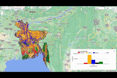
This project leverages Sentinel-1 satellite imagery to accurately map croplands and concrete built areas in Bangladesh at the Upazilla level, providing a comprehensive understanding of land use patterns. By integrating advanced image processing and machine learning techniques, the project aims to enhance market size estimation and supply chain analysis. This will enable the identification of distribution gaps, logistical challenges, and potential sales opportunities in both agricultural and urban sectors, supporting strategic decision-making and improving overall market efficiency.
Key feature of Satellite Data Analysis System:
- Identify potential business market of fertilizer and seeds analysing existing business data and supervised classification
- Identify potential retails store location analysing existing retail stores and other parameters like building area, household areas etc
- Give weather update using statelite data
Simple illustration of the project
N.B: The code for this project can’t be made public for propritory reasons